Wednesday, December 25, 2013

Backpacking the Gore Range (from the archive)

I'm in love with the Gore Range. The North Tenmile Trailhead is 1/4 mile from my condo, so I've spent many days and nights exploring the area from Copper Mountain on the west side to Silverthorne on the east side. In 2009 I studied maps and devised a route that would circumnavigate the Gore Range with only a brief 3-mile hike through Vail to interrupt the wilderness. I got lost above Booth Falls as I tried to cross over the ridge and find Upper Piney Lake and I wound back up in Vail again.
After that failed attempt, a man named Jim Gabriel on Gorerange.info website helped me understand how to find East Booth Pass and thus how to cross over the ridge from Booth Lake to Upper Piney Lake. 
So from August 23-27, 2011, I finally completed this long loop backpack traverse of the Gore Range that I had been eye-balling since I moved to Frisco in 2008.
Here’s a recap of this unforgettable experience.
Day 1: North Tenmile to Eccles Pass
This was an easy head-start day. I hiked in about 3pm from my home in Frisco. Max (my border collie / aussie pup) and I started up the North Tenmile Trail like we have a many times before. I had loaded my heavy 45-pound pack two days before and after hiking up the trail for about 15 minutes, I stopped cold realizing that the lighters I had bought earlier that morning were still sitting on my kitchen counter at home. I was pretty annoyed with myself, but I hid my pack in the woods and jogged back to the house, hoping this wasn’t a bad omen for the days ahead.
So finally about 4pm I was really on my way. I hiked fast and reached Meadow Creek (roughly 7 miles in) near Eccles Pass about 6:30pm and set up camp. I didn’t sleep that well because I was so excited for my first big day on Wednesday. Here is a shot of the Eccles Pass camp where Max is catching some zzz's:

Day 2: Eccles Pass to Upper Piney Lake
I was on the trail a few minutes before 8am and headed directly over Eccles and Red Buffalo passes to get into the Gore Creek drainage. To make this circumnavigation work, I would hike all the way down the Gore Creek trail and through East Vail civilization for three miles to link up with the Booth Creek trail that would take me back into the wilderness for the duration of the trip.
Max @ the Gore Range Trail:

The wildflowers around Eccles Pass were stunning:

Red Mountain from the top of Eccles Pass:

That is Red Buffalo Pass to the left of the above picture, and even though I’ve hiked the Gore Creek trail from Red Buffalo Pass before, I still had some trouble locating the switchbacks down the other side of the pass. My pack was still ridiculously heavy with 6 days of food (I thought it might take that long) so I wasn’t feeling so great hiking down the steep trail. Not long after I reached Gore Creek itself I decided to stop and eat a large batch of trisquits, cheese, and salami. I felt better after this and hiked all the way to Vail before resting again.
It was about 12:30pm when I reached the Gore Creek trailhead. I needed to filter water and eat a decent lunch so stopped for a good while. I had hoped I might be able to hitchhike to the Booth Creek trailhead, but I didn’t see a single pickup truck at the trailhead and I didn’t think anyone would let my wet dog inside their car, so I resigned myself to hiking the boring pavement.
I started up the Booth Creek Trail about 2:15pm. I had still hiked this portion of the route before so I was really just trying to gut it out and get to Booth Lake where everything would become a new experience.. I finally reached the beautiful lake about 5pm after cursing my heavy pack the entire way up that climb.
Max and I had this gorgeous lake all to ourselves:

Booth Lake has a little island in the middle, but I didn't have the guts to brave to cold water to swim over to it:

I ate another snack at Booth Lake and started looking at the map to figure out where East Booth Pass might be over to Upper Piney Lake.  I saw a little green chute that looked reasonable to climb so I decided to try that to see if the tarn was up there that Jim Gabriel had told me to look for. Once into that chute I noticed a cairn so I figured I was on the right track. 

Soon enough I came across the tarn and as Jim said, East Booth Pass was fairly obvious:

It was getting later than I’d hoped so I kept pushing up through the exhaustion. Towards the top I noticed three goats very close-by that were monitoring my progress. 

Once I reached the top I was ecstatic to see Upper Piney Lake directly below: 

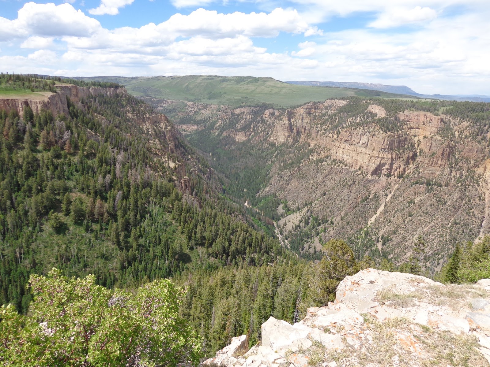
The view from East Booth Pass into the Piney River drainage is amazing:

 The descent was not easy, especially with my heavy pack. Max gave me a wide birth because he quickly learned that I was kicking large rocks down towards him. 
I saw a patch of trees where I suspected I would find a camp, and sure-enough it was there. It was getting late so I threw my tent down, filtered some water, and ate a fine dinner of Buffalo Chicken backpacker meal and peanut M&M’s. I didn’t even have much time to explore the lake at all – that would have to wait until morning.
Day 3: I slept a lot better that night since I was so tired. I think I had hiked about 17-20 miles the day before. This would become the typical mileage from what I can guess.
After breaking camp I hiked over to the beautiful peninsula that almost divides Upper Piney Lake. The little chute to the left is East Booth Pass that I had descended the evening before:

 I spent about 20 minutes soaking in the scenery and taking pictures, but I had learned the day before that the mileage on this hike was going to be huge. To reach my camps, this would become much more like an adventure race than a beautiful hike in the wilderness. I had to keep moving.
The trails up there were faint to nonexistent:

My next goal was to reach Piney Lake for lunch. I pushed through the myriad of braided trails as best I could before one would disappear and I would have to search for the next one. I’m not at all sure that I took the proper trail down the upper part of this drainage, but eventually I did reach the “official” trail where things became easier.
My one almost-serious mishap occurred on a steep sandy section about 30 feet above the bank when I slipped and started sliding down the slope to the river. I had visions of tumbling all the way down to the rocks below, but I was able to slam my hands and feet into the sand and arrest my fall. I scraped up my left hand fairly good, but it could have been much worse. Adrenaline flowing, I pushed on down the trail.
Ate lunch on the banks of the Piney River near Piney Lake. It felt wonderful to put my sandals on and sit in the creek for a bit. The sun was bright and hot, so I soaked my shirt in the creek before taking off again.
Max cooling off in the Piney River:


Here is a shot looking up the Piney River towards the direction I had hiked down from Upper Piney Lake:


Next I would climb the Marugg Creek (called Soda Lakes on my map) trail up and over Elliott Ridge to camp somewhere near Cataract Creek. This steep trail was almost completely overgrown. Once I finally reached the pine forest it became easier to follow. Finally I reached a wet, grassy meadow where there was no longer any discernable trail to follow at all. I knew the Meadow Creek trail was somewhere to my left so I decided to bushwack that way. After a few more minutes I reached the junction with  the trail over Elliott’s Ridge. This trail was a very old double-track that switch-backed over the far west side of the Gore Range. I was not liking the looks of the clouds, but I hadn’t seen a good camp or water source in a long time so I reluctantly kept hiking up, as fast as I could possibly go.
Finally I reached the top of Elliott’s Ridge and I stood mesmerized by the views of Eagles Nest and Mt. Powell:

 I wished I could have explored longer up there, but it soon started thundering and sleeting, so I began running. There was no real trail, but I could see wooden trail markers so I just ran straight for those.
It sleeted hard for about 45 minutes, but I finally got low enough so that I wasn’t too scared of the lighting. I needed to filter water badly so once I felt safe, I stopped at a small creek and refilled.
I had planned to attempt to climb Mt. Powell from this side the next morning. The contour lines on my topo map seemed to indicate it might be possible from Cataract Creek. But after looking up at Mt. Powell and knowing how long the simple mileage of this trek was taking, I decide to nix that idea and get down the trail as far as I could. Mirror Lake became my goal.
I was hustling as fast as I could to reach Mirror Lake. After barely reaching Upper Piney Lake before dark the night before, I really wanted some time to enjoy camp and eat a more liesurely dinner. I got to Mirror Lake about 6:15pm and was happy that I would have almost 2 hours of light to play around. 
Boom! Thunder. Pouring Rain. I set up my tent as fast as I could and tossed everything inside. Max and I waited out a fairly intense thunderstorm before it gave me a brief reprieve right at dusk. I was starving and wanted to eat one of the heavier meals in my pack, so I jumped out and cooked a delicious meal of Tuna w/ shells and cheese before the deluge began again. That’s one thing I learned on this trip: I could eat shells and cheese for every dinner!
Here is a shot of camp during the brief time it was not raining (I would learn the next day that you are not supposed to build fires at Mirror Lake, but since I had come in from the Elliott Ridge side, I did not see the sign telling me that when I got there; that ring was already there so I had assumed I could use it):

It rained hard until late that night and I enjoyed a constant light show through the roof of my tent before finally falling soundly asleep.
Day 4: I thought I had moved ahead of schedule, but this would be short-lived when I could not locate the real trail leaving Upper Cataract Lake. I spent 45 minutes searching for it before finally deciding to bushwack. I knew if I kept the mountainside close on my right and didn’t descend too far then I would eventually hit the Gore Range trail as a worst-case scenario.
Upper Cataract Lake:

This bushwacking took forever. The blowdown was constant. I kept telling myself to be extra-careful because an injury in there and noone would find me for a long, long time. Kindof scary, but I also like that feeling, and its a major reason why I love exploring in the Gore Range.
I finally found the faintest hint of a trail, and was relieved to even see two cairns when I came to a very confusing rockfall / gully crossing. At least I knew some human had been there and was kind enough to direct me to the next section of “trail.”
Eventually I did come out on the Gore Range trail near Tippery Lake, but I had wasted at least two hours.
I ate fast and kept moving. The Gore Range trail is maintained much better than anything I had been for a couple days, so the spaces on my map were passing by much more quickly.
Surprise Lake:


A ridge overlooking the Black Creek Drainage:

Past the Lost Lake Trail… I was moving fast with a lighter pack. It rained hard for awhile and I was soaked from head-to-toe, but I was happy to be making some distance back up.
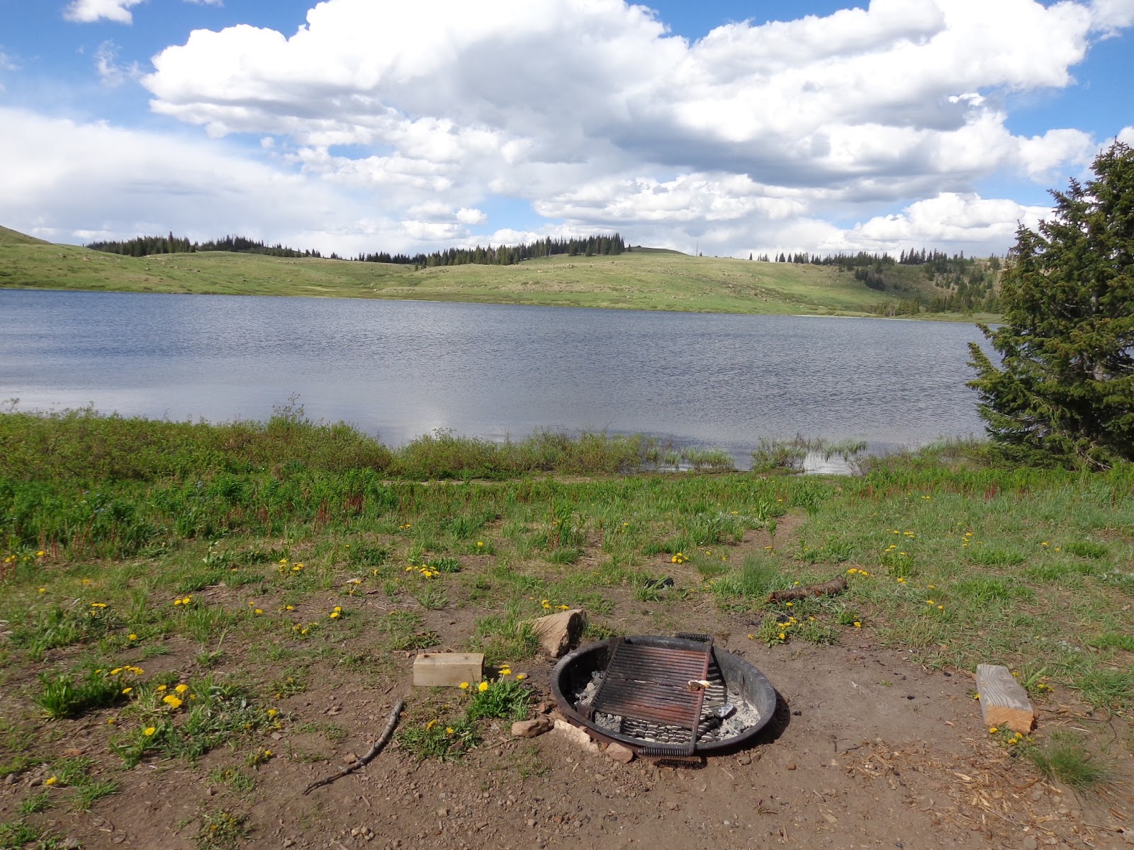
Sometimes jogging when I could, I began to zero-in on Slate Creek. I had camped there a few years before with some fishermen friends of mine and I knew of a great outfitters camp. Once I reached it though, the outfitters were there I searched around and found another good camp on the north side of Slate Creek:

 I ate more shells and cheese and slept like baby. This was the first night that Max stayed inside the tent all night. He curled up next to me and didn’t move until first light.
Day 5: I wondered if I could get home today. I got up earlier and was on the trail just after 7am. I probably felt stronger than I had all trip, other than my aching feet.
Before long I was past Boulder Creek, Rock Creek, South Rock Creek, and I had reached the trailhead for Willow Lakes at 1pm. My original plan was to camp at Willow Lakes and climb over Red Peak the next morning to reach Frisco via Eccles Pass. Thunderstorms were not going to allow me to try that route unless I camped and went for it the next morning. I didn’t want to wait around all day, so I decided to continue on the Gore Range trail all the way to Mesa Cortina and to head home via the Lily Pad Lake Trail.
Finally I got my first look at Buffalo Mountain and I knew that home was just on the other side:

I was just gutting it out at this point. My feet were screaming. I think I was delirious because I hiked about 500 unneccessary vertical feet up Buffalo Mountain because I got confused trying to scoot over to the Lily Pad Lake Trailhead. 
Once Frisco came into view I knew I would make it home and sleep in my own bed that night:

Finally I got out at Meadow Creek and had to hike a mile along the highway to reach home.
I had a blast. This trip was grueling though. I think I wiped Max out pretty good too, because he laid in this position for about three days:


A fantastic trip in an amazing Wilderness!

Random Thoughts & Renewed Focus

Every fall during mud season I seem to lose my focus a bit. Once the trails get covered in snow, but before the skiing gets really good, I distract myself with beer and watching football a lot and get into some bad habits.

This usually takes care of itself after I get into a groove of skinning up the mountain before work. I've gotten in 7 days now so I'm trying to get some momentum and start shaving some of these extra pounds I've put on since I haven't been able to ride my bike.

I have definitely decided that I want to do the Colorado Trail Race again next summer. I daydream about it constantly and I'd really like to see if I can go quite a bit faster this year. Due to a knee injury last winter I was really only able to trail hard from April 1st until mid-July when the CTR began. If I can manage not to hurt myself skiing this winter, I've got plenty of time to get in much better shape than I was last year.

I guess I intend to use this blog now as more than just a CTR training journal. I deactivated from Facebook about a  month ago and I am really liking it. But I had been using Facebook for all my adventure trip photos and I'd like to transition that to this blog.

I think I'll begin that process now, so a few of the coming posts will be about some of my favorite trips in the past. I'll probably start with my big Gore Range Circumnavigation backpack during the summer of 2011.

Tuesday, July 30, 2013

Race Report - Colorado Trail Race 2013

I’ve slept most of the day, besides the few minutes when I was awake and eating, so I thought I’d post up my race report while it’s still painfully fresh.  Sadly, there will be no pictures to accompany as I lost my camera somewhere on day 2. This was after losing my sunglasses on day 1. It wasn’t until losing my knife on day 3 that I would institute a strict, 2-part, sit-you-ass-in-one-place & double-zipper-check break policy that would stem the tide of strewing my gear all over southern Colorado.

Day 1:
As a rookie, I had no idea what to expect, so I took a very conservative start. So conservative that I think I was the very last person to enter the singletrack at Junction. I’m in decent shape, but looking at my fellow competitors at Carver’s, it seemed like I was the fattest dude in the race. I wanted to ride my own tortoise-like pace at the start.

For awhile nothing significant happened until I was hiking up the talus slope on Kennebec Pass. Three day riders were descending quickly towards me when #2 went flying OTB and his bike started tumbling 40-50 feet down the side of the pass. I motioned for the 1st rider to stop so I could tell him what happened to his buddy. He looked back and seemed annoyed, then said, “we’re on a tour, he looks ok (from a 200 yard diagnosis,) the guide is getting his bike, I’m gonna keep going.”

I’m very happy that the CTR racers I met have a higher ethics when it comes to the well being of our fellow competitors.

OK, carried on to Indian Ridge amid some cloud-rumbling but no big epic blasts yet. The tension was building as the rumbling grew louder so I was moving across with urgency. Finally from the saddle between my final ridge and relative safety I witnessed the simultaneous flash-bang of a cloud-to-ground strike right on my last ridge before me. I threw my bike to the ground and grabbed my warm clothes and started running off the side of the trail. I was cliffed-out before I could reach thick forest so I hovered in some bushes rather than the isolated patches of trees. The hail came down in buckets. By the time it was done there was about three inches covering the ground! With the sky still scary, but the rumblings less intense, I made a break for it (thus losing my sunglasses)  and got back to my bike just as Mark Caminiti, Bec & Mike, and a few others were crawling out of their hiding spots too.

So I managed to put myself right into the one huge experience I intended to avoid during the CTR, an intense lightning experience, just a few hours into Day 1.

It took some time to get warm and recover from that, but I had to get some miles in so I pushed pretty late until crashing about midnight at Celebration Lake.

Day 2:
I woke up at 6:30am and my junk was strewn everywhere. I have no idea why I had to unpack everything the night before, but I remember it was 8:06am before I was back to riding on the trail. (I learned a lot to go faster IFFFFFF I ever do this again, so…) BIG-IF LESSON #1: Have your kit organized and ready to leave right when you wake up before sleeping.

I felt pretty crummy as I got going. This would become the pattern as I typically had rough morning and would come around and ride stronger in the early evening into night.

Not far out of Bolam Pass I met Bob Butrico for the first time. He explained that he had slept the night in a rodent-infested miner’s cabin that had looked enticing in his bleery state. I made a mental note to avoid miner’s cabins no matter how enticing. I stopped to take some pictures and he was gone until we would meet again late the next day.

Day 2 was teaching me how friggin’ hard this thing is. I pushed hard over Rolling Mountain Pass to try and avoid any more lighting and was pretty much toast until I finally reached the once mythical town called Silverton.

I didn’t know it at the time, but something good happened to me in Silverton. I ate tons of solid calories and started pushing towards Stony Pass at 4pm. I put on the IPOD and motored up that thing in just over three hours with daylight and energy to spare. I was serenaded by hundreds of baaaahing sheep high on the mountains above me and I stopped and cooked a hot pasta/tuna dinner and had some coffee just as dusk fell.

I put on the lights and the magic happened. I had one of the greatest nights of my life pushing and riding across Cataract. I saw some lights far in front of me, and after awhile I eventually caught up to Cullen Barker who seemed stoked to talk with someone while he was cramming some kind of food down his face. We would ride together all the way to the base of Coney at 2am where we would finally lay down and shiver until daylight.

Day 3:
Since I had “slept” wedged on a slope against a tree I was more than eager to get going on day 3. Cullen looked like he had found an equally crappy place to rest so he was up and moving pretty soon too. As I got higher up Coney, I noticed a decent little string of folks heading up. And as I reached the singletrack segment, two of them started riding their bikes! I thought of how fun that must be as I slogged my 50-pound sidecar to the top. So Ffej & Dax reached the top just as I did. We would spend the next 4 days hop-skotching each other all the way to the finish.

Alas, some amazing riding after Coney summit! Some hideous HAB, but I was numb to that by now. I do think they should declare that little knob called Jarosa Mesa a Wilderness Area – I mean, where else can you find all those gigantic stupid rocks. Big beautiful gigantic stupid rocks – Hidden Gems for sure!

At Spring Creek Pass the construction flagman told me he wouldn’t get water out of the creek there after what the cows had been doing to it all day. So instead, I went down the road a mile or two and got water out of the next cow-crap creek I could find rather than be judged by him.

I flew down the La Garita Detour hill for a few miles, but I was in bad shape after the late night and no sleep so I found a cool spot next to the river and took a 2-hour food and rest break. It was here that I learned BIG-IF LESSON #2: About every 5 hours I needed to stop for an extended food and rest break or my riding/pushing just was not productive. I was starting to learn how to nurse my body through the race and this would pay big dividends.

I finished out the detour as dusk fell, but with little rest from the night before I became very sleepy. Not far past Apple’s I turned down for my longest sleep of the race: 9 hours from 9:30pm to 6:30am.

Day 4:
I wish that my big sleep had turned me into a raging bull, but I was hurting and dragging as I started the relatively easy Cochetopa Hills.

I passed a lady camping who had lost her sandal and she offered to pay me if I saw it and would bring it back. I felt a tiny touch of compassion, but I had already lost my sunglasses, camera, and knife, so the damn sandal better be close. I did see it later just before the section ended, but without having negotiated rates beforehand I trusted she could make due.

THE LOW POINT:
Oh the march to Sargeant’s Mesa. The Anti-flow as Stefan terms it… or my Vaccination Point as Toby Gadd described…. Mark Caminiti said that if I was going to finish that I would become “hardened” at some point. Well marching towards Sargeant’s Mesa is where that happened.

While the mileage/topographical information looked easy, the trail was so sucky as to need its own adjective. HABing downhill on easily rideable slopes was tough. So I just kept pushing and finally it was over.

And after miles of trudging through deep forest, when I reaching Sargeants proper and the tremendous views of the Crest opened up before me, I remember to embrace the beauty. And flying down the trail with my Yeti SB-66C doing what it was born for, I had so much fun again.

Hit Tank 7 at dusk, made another warm meal of rice and tuna, coffee, and pushed happily up some torn up moto-trail for a bivy at Marshall Pass.

Day 5:
I was riding towards the Crest and Fooses by 5:30am, my earliest departure of any day during the race. I could smell a good meal in Buena Vista from 65 miles away. I got a quick shock when I rolled around a blind corner and almost had a head-on collision with SOBO MikeD. He seemed as surprised as I was. I mentioned my goal of reaching BV, and he said something about damn, that is far it took me forever, and I was like yeah, but you had to HIKE UP FOOSES.

So I’m sure I had way more fun on Fooses than Mike did.

I still wasn’t sure I could make BV though. I knew I still had two 20-mile trail sections before getting there. From my experience so far, 20 miles = 7 hours. But lo and behold, the trail got easier at highway 50 and I could ride my bike a lot more. My equations and expectations began to change and 20 miles became more like 4-5 hours instead of half a day

I was talking to the trail like it was a living entity during this section, thanking it and encouraging it to continue giving up some miles.

By 8pm I had a shower and a warm bed right next door to the City Market and I began to think about the finish for the first time. All self-doubt was gone. As long as nothing catastrophic happened to my bike, I knew I was going to finish.

Day 6:
Slept like a baby and woke up at 5am to get the bike ready. Hit the City Market for enough goods to skip Leadville and get to Copper and was back on the trail by 6:45am. The trail section from BV to Tennessee Pass was the last part I had not ridden until the Platte River, but the CT was still giving up some easy miles and for me anyways, I smoked it.

I was worried about the weather for an evening crossing of Kokomo/Searle, so I pushed myself very hard to reach Camp Hale. I figured I could rest in an ammunition bunker through any bad weather and do a night crossing if necessary. It wasn’t necessary though as the weather cleared out beautifully in the afternoon as I hiked up Kokomo.

My effort level would punish me though. I hoped to get over with some daylight to spare, but I had to use the lights for the whole way across to Searle and down to Copper. I had a soul-crushing descent down Searle and traverse of Copper. I’ve ridden that descent probably about 8 other times on day rides, but I crashed a couple times on wet roots before forcing myself into a survival mode to get down.

And let’s not even talk about the most pointless set of switchbacks through the south end of Copper Mountain. Whoever thought that turning a half-mile crow fly into 3 miles of climb over a golf course and lift tower needs to have their head examined.

Cursed my way down to Conoco and slept right outside and dreamed of crushing donuts when they opened in the morning.

Day 7:
Yay, I’m awake, how bout I hike over the Tenmile Range!

I’ve done it several ill-advised times before and it sucks every time, but it still sucked the most this time. The only positive was that I was happy to be doing it in the morning. And I knew it was the only insanely hideous thing left on the course, so just getting it over with gave me a positive attitude.

By now racers were spaced out so far that every random hiker I encountered had to quiz me on just what the hell I was doing carrying my bike with all that gear. I got better with my punchline delivery, “well, we started this thing called the CTR in Durango on Sunday” and it was funny to watch their jaw drop when their brain began to process it. Then I would tell them that I was a mid-pack schmuck and there were people chilling on their couch that finished a couple days ago already. They didn’t appreciate the amazement of that as much as I did, and it kindof depressed me, so later I just let them think I was winning or whatever they wanted.

Clouds were building and the rain began falling as I was climbing Westridge. I kept fighting because I wanted over Georgia Pass with daylight to spare for the descent. I crossed over about 7:00pm and it was pouring buckets. I couldn’t have cared less. I was seizing the remaining daylight to get as far as I could to Kenosha. At the bottom of the big descent I had to put on the lights, but I kept going as my only strategy to stay warm.

Finally I reached Kenosha Pass about 9pm and I knew I would be staying there that night. I had hoped I’d find a huge CDOT backhoe or something to sleep under, but instead I settled for the dry awning aside the Men’s Room.

Day 8:
It continued to pour rain all night.

I awoke when an older fellow needed to take a crap.

I apologized for my current state, but he kindly told me not to worry and he understood that I needed to be dry. Once he came back out he asked how far I had to go and when I said “Denver,” he replied that the weather forecast was rough, but that it wasn’t too far so I should be ok.

I didn’t have the heart to tell him or myself about the Tarryall detour.

I knew the math: 118 miles from Kenosha to the FINISH. It seemed oddly close and far at the same time. There was this road thing, with a lot of downhill, but also a ton of disturbing seismic eruptions to the elevation profile towards the end. So like every other day, I just started pedaling and would let the details sort themselves out later.

I ran into the Pat, Ffej, and Dax at the Stagestop Saloon, and thanked my lucky stars for coffee, warm food, companionship, hospitality, and the ability to dry my socks and gloves in the dryer. Pat deserves some kind of official trail angel status. I walked in the store expecting him to follow me in and track my devouring, but instead he just told me to go in and get whatever I needed and we would settle up at the end. Dude wanted to chill on the porch. That’s the first time I’ve ever bought tons of stuff at a store and then had to point at the trashcan and fifteen empty wrappers to show the clerk all the other stuff I had to pay for.

I didn’t hate the Tarryall Detour. I did go through it on Sunday so I didn’t have to deal with any penalty-box issues like others did though. I voted for it and I probably would again. It rained on me through the burn area, and that wasn’t great, but I suspect a searing sun would be worse.

The finish was pulling me in like a magnet.

Ffej and Dax through down the mojo and once I saw them crossing a ridgeline high above me I knew I’d seen them for the last time.

Finally I was down to 40 miles of singletrack. It was 7:15pm when I was crossing through Buffalo Creek. After an initial blissful descent, I found myself walking much more than I would have liked. The finish kept me positive though.

I reached section 2 and my spirits took another positive leap forward. 28 miles left with a huge net descent and a clean flowing trail. 11:00 pm and I hit the Platte.

For this final section, I was ready to embrace the hike. It just seemed a fitting end to such a trek. My drivetrain sounded suspicious anyways so I didn’t want to break something so close to the end, so I started out just hiking.

As every mile passed my energy and spirits increased. Even after 100+ miles on the day I was starting to charge up slopes that I would have never considered a few days before.

One final HAB over Lenny’s rest stop and then it happened… BAM!

I was on a road. It was gonna be over.

2:15am and there was not a soul at the finish, but that seemed appropriate for some reason. I gave myself a big fist-pump, got out my sleeping bag and went to bed.

7 days, 22 hours, and 15 minutes.


Wednesday, July 17, 2013

Final Pre-Race Thoughts

Tonight I'm relaxing and having a few beers after spending the last three evenings obsessing over gear, how much food to carry, mileage splits, horrific elevation profiles, and how to dodge lighting for a week while riding a couple hundred miles above 12,000 feet during Colorado monsoon season.

I'm nervous about the upcoming challenge, but I'm very excited to get out there and get started. I like my gear-packing system and I feel relieved to have abandoned a silly idea that I might skip resupply in Silverton and try to carry enough food all the way to Buena Vista from the start. That decision has significantly lightened my load.

I know from some prior endurance racing experience that I can push through the first night and into the next evening without sleep if I needed to. With the full moon, I wondered if I might be able to get through Silverton and then continue to push on through the exposed Cataract / Coney segment during the night to reach relative safety before the inevitable electrical storms blow up on Monday afternoon.

But rather than basing this cockeyed plan on mileages and elevation profiles, I finally started digging into hard data from racers that have covered these sections in the last couple CTR's. What I discovered was a stark reality that I better add about 10-15 hours to my estimates for those first 100 miles. So I'm relieved to take that unnecessary pressure off. I'll just carry enough food to get to Silverton and then make my plan for crossing Cataract / Coney once I get there.

So we are heading out for Durango about noon on Friday. I am sharing a one-way rental and a motel with two other racers from the front range. One is a rookie like me, and the other is a multi-year CTR veteran. It will be nice to pick his brain on the ride down.

Even though I was actually in better riding shape last summer, my mindset in good. Although I am competitive and want to go as fast as I reasonably can, racing other people is not really my goal. Finishing is my goal. I can't really remember quitting any competitive event I have ever started, so even though the toughness of the CTR makes that a distinct possibility, I refuse to let that enter my mind right now.

I have no arbitrary time pressure. I've taken off work until August 5th, so barring injury or serious illness, I have enough time to finish this thing. I want to remind myself to have fun and enjoy my time in the wilderness, and to just keep making progress towards Denver. I know there will be some serious low points, but I have to persevere.

Its going to be beautiful to a spiritual level out there. Its going to be the most amazing adventure of my life.

I'll take lots of pictures and check back in on the flipside.

For in-race coverage, go here: http://trackleaders.com/ctr13

CTR Gear List

After several rounds of mock-packing I've finalized my gear list. Hat tip to Toby Gadd since I used his list as a template to develop my own.

Bike:
Yeti SB-66C
Maxxis Ardent 2.4 w/ EXO protection on front
Maxxis Ardent 2.25 w/ EXO protection on back

Luggage:
Cleaveland Mountaineering Bar Sling and Bag (sleep system, water filter, batteries, tp)
Cleaveland Mountaineering Large Seat Bag (clothes)
Revelate Designs Gastank (camera, Honey Stingers, almonds, ipod)
Dakine Apex 1600cu in Hydration Backpack (tools, spare parts, food)
(2) 13L Sea to Summit Ultrasil Nano Drysacks
(1) 8L Sea to Summit Ultrasil Nano Drysack
(2) 10L Sea to Summit Event Compression Drysacks

Sleep System (whole thing is 3.5 pounds):
Sea to Summit Micro II Sleeping Bag (AWESOME! compresses to size of a water bottle, but warm!)
Thermarest Neo-Air X-Lite Inflatable Sleeping Pad
Marmot Alpinist Bivy Sack

Hydration:
100oz bladder
Spare 50oz bladder
MSR Hyperflow Microfilter
30 MSR Aquatabs

Clothing:
Helmet
Gloves
Pearl Izumi X-Alp Enduro Shoes
Short Sleeve Jersey
Bike Shorts
Wool Socks
Watch
Marmot Super Mica Rain Jacket (packed)
Marmot Minimilist Rain Pant cut off below the knee (packed)
Patagonia Synthetic Jacket (packed)
Extra Chamois (packed)
Long Sleeve REI Quickdry Shirt (packed)
Thin Tights (packed)
(2) Extra Sock (packed)
Fat Tire Visor
Warm Gloves
Warm Beanie

Navigation:
Garmin Etrex 20 GPS w/ Toby Gadd CTR track
Colorado Trail Databook
Spot 2 Tracking Beacon
Backup Maps
Cygolite 750 lumen headlamp w/ extra battery for 36 hours of light on low power.

Toolkit and Spare Parts:
Park multitool, chain tool, and other small wrenches
Minipump
Chain lube
Zip Ties
Patch Kit
(2) Tire Boots
(3) Extra Tubes (1 is ultralight)
Derailleur Hanger
Shifter Cable
(2) Brake Pads
Extra Chain and Quicklinks (heavy, but good peace of mind)
Shoe Cleats and Bolts
Duct Tape
Small Rag

Camping and Other:
MSR Pocket Rocket Stove and Fuel Canister (got to have coffee)
Small Pot to heat water
Coffee Cup
Sea to Summit Spork
Sunglasses
Sunscreen
Lip Balm
Toothbrush and Toothpaste
Toilet Paper
Wet Wipes
First Aid Kit w/ insect repellant
Ibuprofen and Alleve
Camera
Ipod
Cell Phone
Device Charger powered by AA Batteries (phone, ipod, lights)
Cash, Drivers License, Credit Cards, Health Insurance Card
Extra Batteries
Small headlamp for camp use
Knife
Lighter and Waterproof Matches

Food (for the trek to Silverton, plus a bit more; approximately 13,000 calories):
Coffee
(10) Honey Stinger Bites
(2) PB&Honey Sandwiches
(2) 8oz Blocks Extra Sharp Cheddar
(2) 5oz Pepperoni Packs
Trisquits
(2) Snickers
(2) Peanut M&Ms
(2) Skittles
(2) Cajun Trail Mix
Salted Almonds
(6) Flour Tortillas
(8) Tuna w/ Olive Oil
(2) Lipton Instant Pasta Packs

Sunday, July 7, 2013

Firecracker, Trestle and Peak One

My annual Firecracker 50 was a disaster.

Felt good the first lap. Despite the heaviest, most impassable traffic I ever remember during that lap I still came in at 2:35, just a few minutes slower than last year. That was about what I expected.

I hit my aid-station truck at the ice rink before lap 2 and ate a banana, half a Snickers, took an alleve and a couple caps of Sportlegs.

OK great, heading back up Boreas Pass Road for lap 2... feeling some fatigue but about normal. Not far past the lower Bakers Tank TH and my vision started closing in. A rider passed me and I could hardly see him. And I really got freaked when I heard a car pass by me going downhill and I didn't see it at all. I thought I felt ok, but I was going freakin' blind. I needed to pee anyways so I pulled over and faked a cramp. 

The details are hazy, but I remember thinking that my "race" was over but I just needed to drink and eat and get my shit together so I could finish. Quitting is just not an option. I was bumping into unseen logs and the thought of descending fast singletrack was preposterous, but I just rested and drank and ate and slowly it started coming back.

Dehydration is the only thing I can figure. My confidence was pretty much shot but I got back on the bike and kept riding. I would grab on to someone's wheel and just follow them. It felt better to follow someone. Probably ten times the rider in front would ask me if I wanted a pass, but I would just tell them I was hurting and just trying to finish. Sortof true, but my body felt decent. I just couldn't see.

First Lap = 2:35; 2nd lap = 3:45 for a 6:20 finish. Just horrible and a full 1hour15min slower than last year.

I drank about 10 gatorades and still woke up peeing brown the next morning so I'll chalk it up to a bad day and severe dehydration. 

Friday I met some friends at Winter Park's Trestle Bike Park and crushed downhill all day. Had so much fun! Rode all day and by the end I was clearing the huge jumps. I rented a World Cup DH bike and that's the first time I've ever ridden a bike with 9 inches of travel. Certainly bails you out if you land short.


I was feeling pretty worked when I woke up this morning. I drank some coffee and tried to rally my sore body to meet some friends for a Mt. Guyot circumnavigation ride. General sleepiness won over and I climbed back in the sack until about noon.

Later this afternoon I geared up for a long hike with Max and set out for a bushwack hike to the ninja cairn trail that leads from Frisco to the huge amphitheatre below Peak 1.

Once I got there I was surprised that the weather had totally cleared. And Peak 1 was so close.

So I climbed the south ridge of Peak 1 and summited that mountain for the 9th time. Really great hike considering I never set out for anything that ambitious.

2 weeks from today for the start of the Colorado Trail Race. I won't allow my Firecracker 50 experience to become worrisome. Rather, I look back happily on my stubbornness that allowed me to finish.

Stubbornness will be my greatest asset in the CTR.;

Monday, July 1, 2013

Crestone Needle - 14,197

Had another solid weekend. Pre-rode the Firecracker 50 course on Friday and did a hard effort ride to Vail Village and back where I chopped 27 minutes off my best time ever. Granted, I have a carbon 29-er hardtail I'm using for pavement stuff this year, and last year I was still riding my 7-year old Specialized FSR, but 27  minutes is a lot of time to chop off regardless.

The highlight of the weekend was a climb of Crestone Needle on Saturday though. My buddy Jeb is making a strong push to finish off the last few 14-teeners he needs to complete them all, and I didn't want to miss the chance to climb the Needle with him. I also figured it would be decent HAB practice for the CTR so I didn't mind skipping a ride on Saturday.

We left Summit County Friday evening about 7:30 and got to the trailhead at 11:00pm. I laid out my bivy on the dirt and we set the alarm for 3:30am. After a little snoozing and gear-prep, we were hiking up the trail at 4:15am.

We made excellent time and had reached Upper South Colony Lake by about 5:45, just as the sunrise was starting to light up the Needle:


Broken Hand Pass was looking super-steep, but we kept up a solid pace and got there at 6:45am. I was happy that there was no difficult snow to deal with because I didn't have an axe or crampons. Luckily, it was just steep. Here's Jeb scoping out the tight section at the top:


We stopped and ate for about 15 minutes at the top of the pass, but soon continued on. From Broken Hand Pass @ 12,900', there is a good climber's trail that weaves around and avoids the lower cliffs until you reach the bottom of a large gully @ 13,300'.


From there you just start climbing on the wonderfully solid conglomerate rock. Supposedly the easiest way is to continue up gully #1, then climb over a rock rib into gully #2 for the rest of the way to the summit. I don't remember ever switching gullies, so maybe we just stayed in the first one. We did climb a few sustained class 4 sections, so I'm not sure we took the "easiest" way. But as I said earlier, the rock on Crestone Needle is amazing solid so I was comfortable and having fun the entire time.

Here are a few looks at the terrain on the steep final 900' to the summit:


It was only 1 hour from Broken Hand Pass and we made the summit right at 8am after 3 hours 45 minutes from the trailhead. The weather forecast wasn't great for the day, and it was already looking like something might come together, so we didn't hang out for too long. We just ate some Honey Stingers and decided that we'd get down to Upper South Colony Lake before breaking out lunch.


Total trip was 12.5 miles in 7 hours and 15 minutes. A great day in the Sangre de Christo's.

This was my 28th ranked 14-teener, and leaves just Crestone Peak and Kit Karson left to climb in the Crestone group. I need to figure out a way to combine those.

Tuesday, June 25, 2013

Bikepacking - Coffee Pot Road into the Flat Tops

Its been a little while without posting, but things are going well with the training. I've gotten in a few 50 mile MTB rides with 6000' or more of climbing and my weight is down to 168. So I've been making some good progress. Less than a month to go before we line up in Durango, so last weekend was a good time to get out with the gear bags and a loaded down bike and go for an overnighter.

I didn't have anyone to watch my dog, so I had to keep the trip into a roughly 24-hr period. I scoured the maps to find a good ride with a long climb to test the legs with the heavy bike. A friend suggested that I look at the Flat Tops over by Dotsero, so I broke out the maps and decided on a trip up Coffee Pot Road.

Coffee Pot Road starts at 6300' and climbs relentlessly to 10,100' before continuing on up through rolling terrain to a high point of 10,700'. I figured this would get me at least 5000' of climbing on day 1 with the bonus of sending me to an amazing area to camp and explore more the next day.

I took my dog Max for a 5.5 mile hike early Saturday morning so he would wear himself out, and then headed over to Dotsero and began my climb up Coffee Pot Road at 12:30pm. I was encouraged that I was able to climb just fine even with the heavy bike and never had to reach into the easiest of my granny gears. I passed through pinon and juniper and up through the aspen and spruce before reaching Deep Creek Overlook after 15 miles, 2.5 hours, and almost 4000' of climbing.


View of Deep Creek 2500' below:


I took in the views, ate a PBJ, and got my stoke on to have the big climb over and to be up top with the rolling terrain like this:


The views were opening up in every direction to the Sawatch, the Elks, and the Southern Flat Tops. There was water everywhere and I was thoroughly enjoying the ride as I rolled in the Crane Park.


I rolled up on Deep Lake after about 28 total miles and a little over 4 hours. I filtered a full bladder of water and watched a group of 20-somethings "fishing" by chunking boulders at fish in the stream inlet. I'm not sure if they had any luck with that method.

Here is Deep Lake:

From there, Coffee Pot Road would start to descend for 10 miles and 1700' to its dead-end at the South Fork of the White River and Budges Resort. The wilderness was getting much deeper and more beautiful, so I started scoping out potential campsites on the way down. I saw several fine ones, but wasn't ready to stop yet so I just kept on going down.

About halfway down you reach Indian Pass Camp at 9750':


You are surrounded on all sides by the Flat Tops Wilderness area and it is stunningly beautiful. Someone already had the best campsite at Indian Pass and I was in the mood to keep exploring so I decided to take Coffee Pot Road all the way to the end.


I had read that a cabin at Budges was $250 a night, so any fleeting thoughts of kicking back in style were quickly dismissed. The terrain had flattened out in the valley and I could tell there had to be great campsites all around. I carried my bike about 100 yards to a line of trees next to Wagonwheel Creek and sure enough:


And for all the times I've donated my leftover firewood, someone had kindly paid it forward to me:


It was about 7pm so I had plenty of time to explore the valley, the South Fork of the White River, and odd random skeletons resting in the woods behind my site:


Any clue what this is? I'm a little rusty on my wilderness skeletons.


I cooked up my favorite backcountry meal, shells and cheese with Tuna, enjoyed a small campfire, and tried to stay awake long enough to watch the rise of the Supermoon. I waited as long as I could, but it was still deep in the trees at 10:00pm and the bivy was calling.

I set my alarm for 4am and slept fantastic all the way. It was chilly enough to freeze the hose on my hydration pack, but by telling myself I better prepare for the CTR, I was out of the bivy, packed, and riding back out of the basin at the slightest hint of light.

I felt awesome. Its rare that I ride that early and it was fun and invigorating to watch the sun gradually brighten the day. I took a detour from Coffee Pot Road on the way out and was blessed to reach the amazing Heart Lake at 7:00am. 

Wow, what a beautiful place:

I took a longer route on the way out ('course I didn't have to start with a 5000' climb,) looping down White Owl Road to the Grizzly Cow Camp 4-wheel drive road. Grizzly Cow Camp was a weathered, crumbling group of 3 old buildings in another amazing valley at the head of a waterfall on Grizzly Creek.


Grizzly Jeep Road eventually dumped back into Coffee Pot Road for the final 20 miles back down to the truck. The 15-mile climb that took 2.5 hours turned into a 33 minute descent - and despite the gravel road, 4000' descents are just fun, I don't care who you are!

So I was back to the truck at 11:00am. Day 2 was 42 miles, so I covered 80 miles in less than 24 hours. Granted, there was zero singletrack, but my goal was really just to get in some good climbing and to lay down some miles.

I'll be back here to explore more and I highly recommend it to anyone. I might not climb from Dotsero next time, but I barely scratched the surface of the roads and trails up top and they beg to be explored.